HIKE JAPAN’S IZU PENINSULA SERIES Part.6_Hakone Hachiri (Kannami/Mishima)
Hakone Hachiri (Kannami/Mishima)
HIKE JAPAN’S IZU PENINSULA SERIES
Izu Peninsula UNESCO Global Geopark
Japan’s Izu Peninsula, just 45 minutes from Tokyo by bullet train, is geographically unique in being the only part of the mainland to sit on top of the Philippine’s tectonic plate. Izu was originally an island located south of the Japanese mainland. The northward movement of the Philippine plate eventually brought the island into contact with the mainland, forming the current peninsula. Understandably, a considerable amount of volcanic activity manifests in this movement, earning Izu Peninsula UNESCO Global Geopark status.
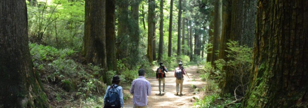
Cedar Avenue
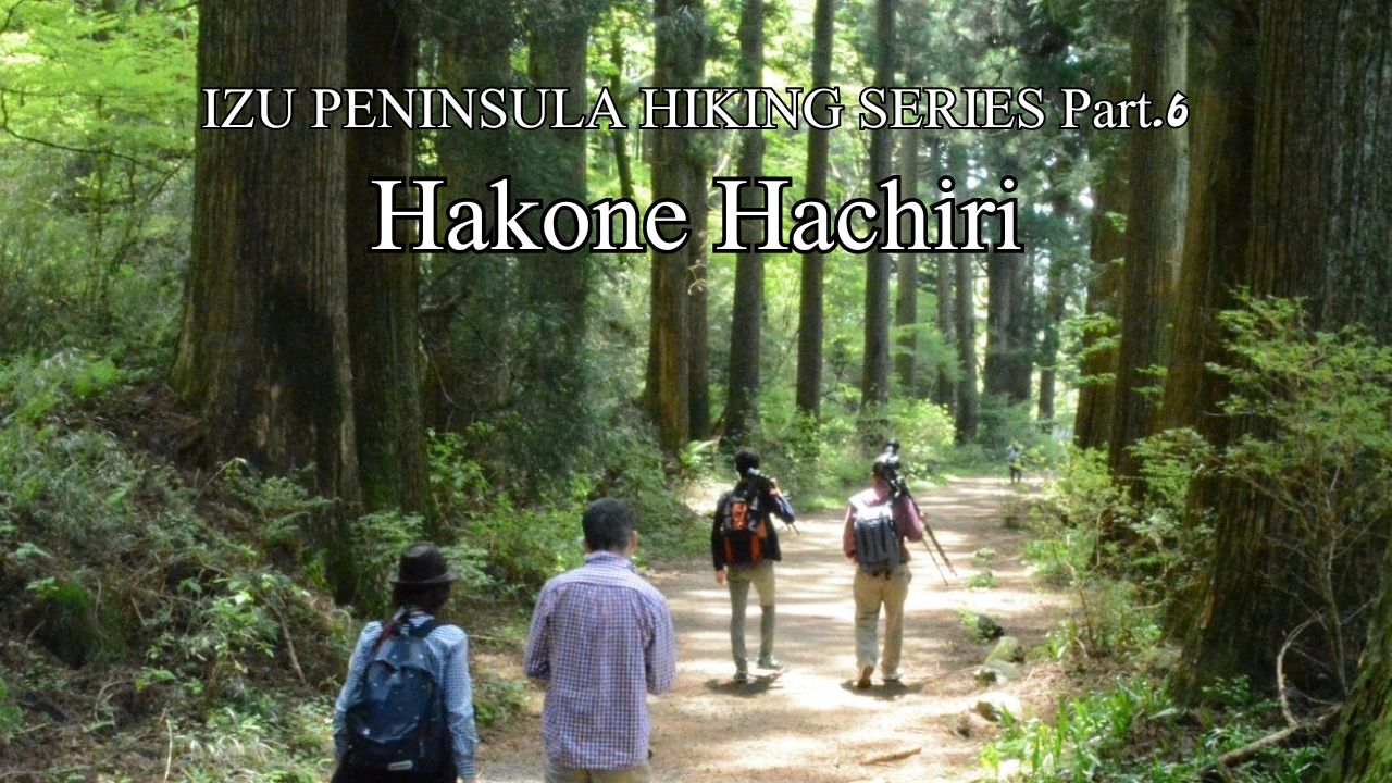
For five centuries Old Tokaido highway has linked Japan’s modern capital of Tokyo with the ancient capital of Kyoto. In feudal times most travelers of Tokaido were on foot – horses or palanquins being a luxury for the elite only. A section of old Tokaido close to Tokyo known as Hakone Hachiri has recently been declared a Japan Heritage Area. In Japanese, Hachi means 8 and ri is a unit of distance equivalent to about 4km (2.5 miles). So Hakone Hachiri is the 32km (20 mile) stretch of Old Tokaido between Odawara and Mishima (a setting in James Clavell’s epic novel “Shogun “), via Hakone. Hakone Hachiri has been declared a Japan Heritage Area.
We start today’s program from Moto Hakone bus terminus so we can make a day hike through the remaining forested parts of the 32km Hakone Hachiri (much of which is now covered by a modern road). From the bus terminus head west (our direction all day) along the lakeside, following the towering Japanese cedar (sugi, Cryptomeria japonica) lining our path on both sides. Soon our walking path (Old Tokaido foot highway) diverges from the road to the left and continues through the cedars, which are called “Sugi” in Japanese. There are over 400 of these towering beauties lining our trail both sides for over a kilometre, this opening section of our walk appropriately known as Cedar Avenue. They were planted in 1618, at the order of the 2nd Shogun of the Edo (Tokyo) Era, to shelter Tokaido walkers. Sugi is a wonderful tree, capable of living thousands of years as proven by the giants in the World Heritage Yakushima Island down in the south of Japan. Over 70% of Japan’s land area is in plantation forest, much of it sugi, creating a great carbon sink and fibre/fuel resource for future generations. Unfortunately, these plantations get a bad rap for the pollen they produce in Spring stimulating hay fever. But for now, enjoy the Redwoods-like cathedral effect along this section of our trail.
As you dive left into Cedar Avenue, where the walking path separates from the modern road, look carefully to your left and you can see a small stone monolith. This is a distance marker. In feudal times these markers were placed every “ri” (4kms) along the route.
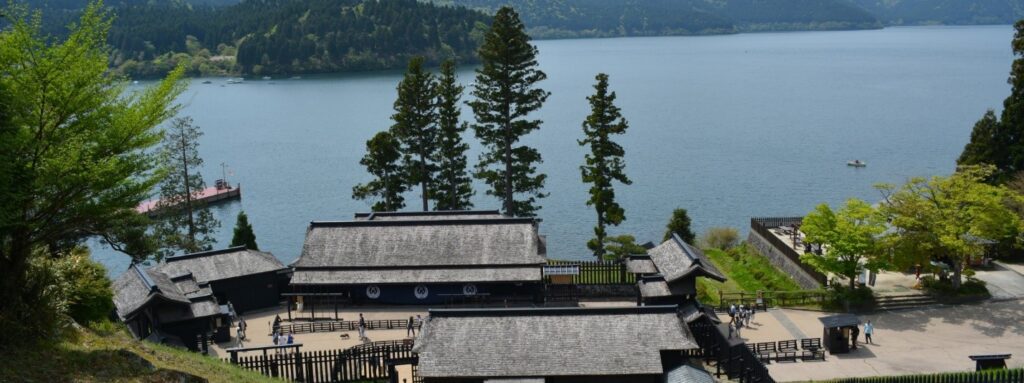
Hakone Checkpoint
Soon you arrive at Hakone Checkpoint. The mantra of the officials inspecting travelers at this checkpoint was “no guns into Edo, no women out”. There were many checkpoints along the old highway, but this one is the last one before reaching Edo (Tokyo) when walking in the opposite direction from us, ie. from the west. The Shogun in Tokyo was paranoid about assassins or coups getting into the capital. In order to keep the far-flung local Lords of Japan under control, the Shogun required them each to send a hostage to the capital, a female relative (a wife or mother or sister etc.) To prevent these hostages escaping the capital disguised as a common woman, no women were allowed out. Stroll through this faithful recreation of the wooden checkpoint on the original stone foundations from feudal times.
Carry on along the road through Hakone Machi after the checkpoint, soon you are back under the mighty sugi and climbing up and out of the massive Hakone caldera. On sloping terrain the Old Tokaido was paved with cobble stones, although when wet these can be a bit slippery, take care. At the top of the hill (caldera lip) you cross the Prefectural boundary from Kanagawa Prefecture into Shizuoka Prefecture, ie. from Hakone township into Kannami township. At this point you are walking again on the road, check out the State Highway number, it’s #1. This road has been Japan’s main drag for half a millennium, and still is. Having climbed up and out of the Hakone caldera, our journey for the rest of the day is down the outside slope of the volcano to its base at our journey’s end at Mishima.
A kilometre down our cobble-stoned Tokaido brings us to a place labelled as “Settai Chaya”, literally meaning entertaining tea-house. In days gone by, a timely establishment to stop for tea, particularly for travelers coming the other direction from the west, who have ground their way uphill 12kms from Mishima, up the concave outside slope of Hakone volcano. Regrettably the tea-house has gone, but note the mound here, another “ri” (4kms) marker. We have walked 4kms from the last marker back at Cedar Avenue. Also, you’ll see a large rock here in the shape of a samurai helmet. It’s said that some of Japan’s most famous samurai have rested their own helmets on this rock as they have moved through Old Tokaido here to conquer new lands.
Carry on down Old Tokaido, at one point our path dissects someone’s private garden. Enjoy the copious seasonal flowers they have painstakingly nurtured for us. A little farther along you’ll come across a gravestone on the right-hand side of the trail, with a sake bottle engraved on it. The Japanese-only sign tells us that this is the grave of a palanquin bearer along this section of the Tokaido, who was very kind and helpful to the local people, so they built this monument to him. You can see fresh bottles of sake left for him even by today’s town folk, because he liked to drink. It’s said that over the centuries the exact location of the grave has moved around this area a bit, as though he is still stumbling around drunk in the after-life. Judging by the size of the sugi planted next to his grave, which is about the same size as those back on Cedar Avenue, we can estimate that our hero lived here about four centuries ago.
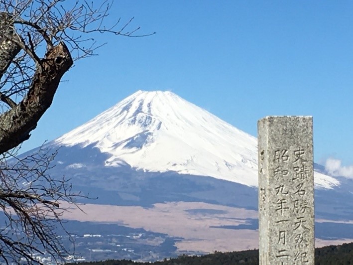
Mt Fuji from Yamanaka Castle Ruins
At this point Old Tokaido passes through Yamanaka Castle (meaning literally “on the mountain” castle) ruins, situated here to keep an eye on traffic coming along Tokaido from the west. By 1590 the Lord of Osaka had united all of Japan under his rule after 2 centuries of Warring States Period, except for this eastern corner of the country. The local Lord (based in Odawara Castle) refused to submit to Osaka, so a force “of a size never seen before” (believed to be about 200,000 strong) was dispatched to deal with the uncooperative eastern vasal. Coming west from Osaka to deal to Odawara along Old Tokaido, the force first of all had to topple Yamanaka Castle, western sentry point of the local Odawara Lord. Despite some clever earthwork defenses you can still enjoy as you stroll through the castle ruins, the lightly defended Yamanaka Castle was overwhelmed by the numbers from the west, and what you see now is all that survived. The force went on to topple Odawara Castle itself, and as a reward to his general that led the battle, Osaka Lord gifted him the lands of the now defeated eastern Lord. The General looked at Odawara, but decided to set up his new base a little further east in the land he had bestowed, at an unknown tiny fishing village called Edo. Today we call it Tokyo. The General went on to become Japan’s most famous Shogun (subject of James Clavell’s 1975 epic historical fiction novel of the same title, and 1980 TV miniseries staring Richard Chamberlain).
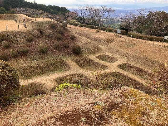
Waffle maker in Yamanaka castle ruins.
As you walk through the castle ruins, you’ll notice earth structures that today are colloquially referred to as waffle makers. As a mountain castle, there was no water source for classical water moat defenses. These earthen defenses work by forcing the attackers into single file, allowing defenders to pick them off one by one with arrows or guns. Clever, but not enough to offset the overwhelming numerical advantage of the attackers from the west, and the rest, as they say is history.
By the way, on a clear day there is a great view of Mt Fuji from the highest point of the castle ruins. Outside winter months, there is only a 20% chance of seeing our secretive mountain, as she ascends steeply from the Pacific Ocean (Suruga Bay to our left) and therefore rising moisture from the sea often cloaks Fuji in cloud. Fuji is a relatively new feature, about 10,000 years old, making her the much younger sister of the Hakone volcano we are walking down, which, whilst still slightly active today, had her big caldera-forming eruption a few hundred thousand years ago.
Carrying on down and west, we come across Mishima Skywalk, Japan’s longest pedestrian suspension bridge and a modern feature on our ancient route. Another great Fuji viewing opportunity, weather permitting of course. We’ve walked about 7kms so far today, so jump on the bus from the Skywalk heading towards Mishima, getting off at Mishima Taisha in the outskirts of the city.
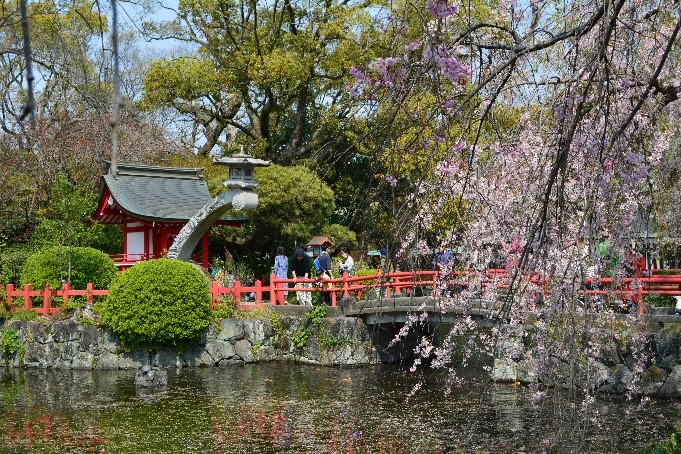
Mishima Taisha in Spring
Mishima Taisha is an important shrine as you might gather from the size of the grounds. Beautiful Sakura blossoms in Spring. The Shrine was a place of worship for first warload who established Samurai’s administration, way back in the 12th century. The (paid entry) museum on site displays documents clearly showing his signature (in Japanese of course). He grew up in this Izu area.
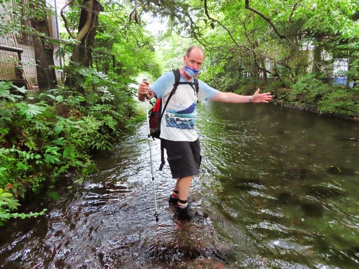
Walking on water, Genbegawa World Water System Heritage
From the Taisha wind your way for a little bit around the back streets of Mishima to Genbe River. A kilometre-long stroll along this delightful little river brings us to our destination at Mishima Station. Genbe River has achieved World Water System Heritage status. This area used to be the industrial heartland of Japan, so back in the 1960s and 1970s the river became very polluted as local factories churned out consumer goods for the world. The locals, however, in the 1990s made a big effort to clean it up again and return the river to its original pristine state, earning the World Heritage bong. Look closely and you can see the river is fed from spring water bubbling out between lava sheets that have flowed down from Mt Fuji. In many places the walking route along the river is stepping stones that go right down the middle, very cool. The river walk finishes at Rakujuen Park (paid entry), which is the preserved garden of the 19th century Emperor’s cousin’s holiday home. It’s also the main spring water source of the Genbe River we have just walked along. The exit from Rakujuen brings us out in front of Mishima Station. But why hurry home. How about staying a night and enjoying another nearby Izu hike tomorrow?
Hakone Hachiri is great for individual hikers, or if you would prefer a guided hike try Hike Hakone Hachiri.
Name: Hakone Hachiri
Starting point: Moto Hakone Bus Terminus
Finishing point: Mishima Station
Access: Odakyu train from Shinjuku to Hakone Yumoto (Romance Car luxury express or local train), bus to Moto Hakone
Length: 9 kms 6 hours (including time at Skywalk and bus to Mishima)
Terrain: up and down Mt Hakone Volcano, half-millennium old cobble stones on the old foot highway can be slippery when wet, poles useful for stability.
Difficulty: Moderate
Onsen close by: Atami, Shuzenji
Other hikes in same vicinity to make multi-day program: