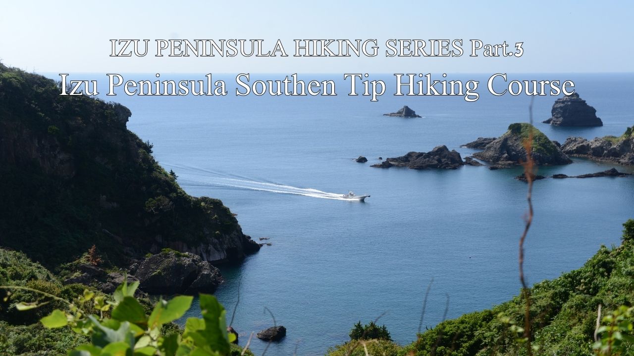
HIKE JAPAN’S IZU PENINSULA SERIES Part.3_Izu Peninsula Southern Tip Hiking Course
Izu Peninsula Southern Tip Hiking Course (Minami Izu)
HIKE JAPAN’S IZU PENINSULA SERIES
Izu Peninsula UNESCO Global Geopark
Japan’s Izu Peninsula, just 45 minutes from Tokyo by bullet train, is geographically unique in being the only part of the mainland to sit on top of the Philippine’s tectonic plate. Izu was originally an island located south of the Japanese mainland. The northward movement of the Philippine plate eventually brought the island into contact with the mainland, forming the current peninsula. Understandably, a considerable amount of volcanic activity manifests in this movement, earning Izu Peninsula UNESCO Global Geopark status.
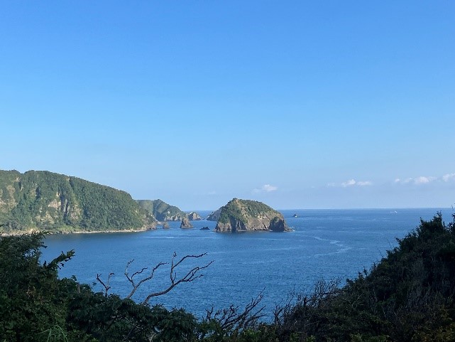
All along today’s route enjoy spectacular vistas of Izu Peninsula’s southern coast and cliffs.
Enjoy hiking along the absolute southern tip of Izu Peninsula Geopark. This up and down clifftop walk affords spectacular 180-degree views east-south-west over the Pacific throughout its length. Pick out the different strata in cliff-faces along the route that silently tell the story of the Peninsula’s violent volcanic development over eons. Pass through quiet little fishing villages where the locals will barely look up from fixing their nets as you stroll by. Minami (south) Izu is a more remote part of the Peninsula (no direct train access and farther from Tokyo than the east coast) so it feels like a time-slip back to a quieter, simpler coastal lifestyle.
From Tokyo catch Odoriko to Shimoda Station, or Tokaido Shinkansen to Atami Station and then the local train down the east coast of Izu Peninsula to Shimoda. The hour+ ride from Atami to Shimoda affords nice views of the Pacific all along the route, a portent of our hike to come. From Shimoda Station catch the local bus to Irozaki Port (buses run approximately hourly), takes about 30 minutes. Alight at the Port and catch your breath in this quiet extreme of Izu Penisula. You are greeted by a statue of En Gyoja, a mythical character who apparently long ago flew into this area on a shell, to give respite to the people suffering from an endemic (sound familiar?). On the eastern side of the Port observe caves carved into the cliff-face. In 1945 these caves stored small fast Kami Kaze boats loaded with explosives that were intended to target US navy vessels invading nearby Tokyo Bay. Fortunately for all, Japan’s unconditional surrender on August 15 preempted the need.
A pretty stroll up the several hundred metre well-paved slope beginning from the western side of the Port car park brings you to Irozaki Ocean Park. There is a nice café where you can refresh with views of the Pacific and an informative area about Izu Geopark. Walk out to the extreme tip of Cape Irozaki and feel the exhilaration of the mighty Pacific surrounding you on three sides, a little like Jack and Rose in Titanic (although of course that was the Atlantic). On a fine day enjoy picking out various of the Izu Islands using the diorama as a guide to their names. A cute shrine clings precariously to the cliff-face here, braving all to pray for safe passage for sea-farers. The shrine is partly supported by a spiritual hinoki log recovered a couple of centuries ago as it drifted around the Cape from its origin in western Japan.
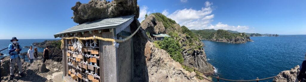
This cute shrine clings precariously to the cliff-face at Cape Irozaki.
Let’s start our hike in earnest with about a kilometre walk along the main road heading eastwards, our direction all day today. On the right-hand side of the road find the start of the trail. There is a solid information board there explaining the route so that you know you are in the right place even though the entrance to the trail may be obscured by long grass. Push through the grass for about 50m and once under the trees the trail becomes clear. It is about a 2km hike through some volcanically interesting terrain down to the small fishing village on Nakagi. Along the way keep an eye open for the remains of several feudal period charcoal cauldrons which processed the forests of Izu into fuel for Japan’s capital not so far away to the east.
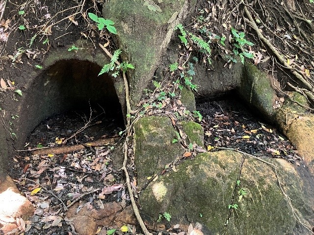
Feudal era charcoal cauldrons beside our trail.
Emerging into Nakagi affords a precious glimpse of life in an isolated Japanese fishing port. Most of the fishing action happens very early in the morning so by the time you arrive here the Port has become the domain of a few hardy water enthusiasts largely from Tokyo. Walk the length of the small waterfront, take the staircase up to the small temple at the eastern end of the bay and you can see our trail as it disappears off into the coastal forest once again. Another 3km cliff-top hike from Nakagi to the next small fishing port of Iruma. Shortly after climbing up to the top of the cliff from Nakagi, now behind us, you will come across an ancient buddhist prayer spot carved out of the rock which looks like a mini Angkor Wat. The sign tells us that people in the old says prayed here for a safe ocean trip. Rest of the walk through to Iruma periodically provides spectacular views of the Pacific coast, highlighted by dramatic cliffs of different colours representing the various strata that have formed today’s Peninsula.
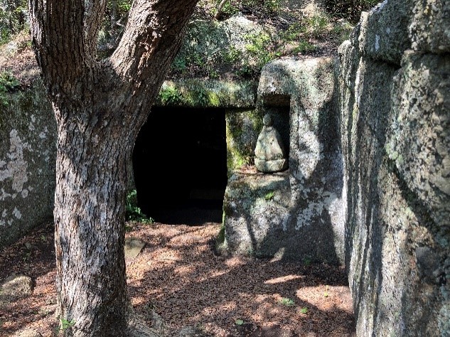
Ancient buddhist spot to pray for safe passage.
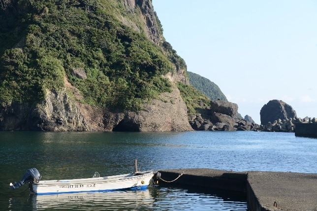
Life is peaceful at Iruma fishing port.
Dropping down into Iruma you are treated to an even quieter quaint fishing village than Nakagi behind us. Once again walk the short length of the bay and pick up our trail on the eastern side. About a 30 minute walk brings us to the turn-off to Senjojiki, and a further 15 minutes down a very steep staircase (with a sheer drop off the side) brings you to this geological feature just above high-tide mark. Senjojiki literally means “a thousand tatami mats laid down” because that is what the rock platform looks like. Evidence of excavation over the eons is everywhere – Izu stone being a valued construction material in feudal Edo (now Tokyo) because of its easy working properties and also ease of transport to the capital by sea. Back up the staircase to where we turned off.
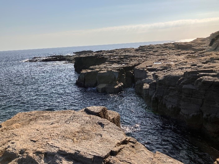
Senjojiki
At this point, if you are adventurous you may like to continue eastwards for another couple of kilometres to the next small town of Yoshida. Be advised however that this part of the trail traverses a cliff-face, so if anyone in your group doesn’t have a good head for heights you may prefer to turn about here and retrace your route back to Iruma. The bus service from Iruma is limited to just a few services a day, so if your timing doesn’t work out for that option you could call a taxi to take you back to Shimoda Station. Or of course overnight right here in Minami Izu to relax in the laid-back rural environment with a sub-tropical Pacific feel.
Name: South Izu Clifftop Hike
Starting point: Irozaki Port
Finishing point: Iruma Village
Access: Odoriko to Shimoda Station, bus to Irozaki Port
Length: 10kms 5hours
Terrain: up-down cliff-top hike
Difficulty: Medium strenuous. A good head for heights is required if you wish to complete the last 2kms of the trail into Yoshida, and/or the side-track down to Senjojiki.
Onsen close by:
Other hikes in same vicinity to make multi-day program:
Yumigahama
Old Shimoda Foot Highway & 7 Falls (Izu/Kawazu)